Welcome Visitor. First time here? Like what you see? Bookmark us for when you are bored, and check out 'top shots' and 'fantastic (editors choice)' in the menu above, you won't be dissapointed. Join our community! click here to sign up for an account today. Sick of this message? Get rid of it by logging-in here.


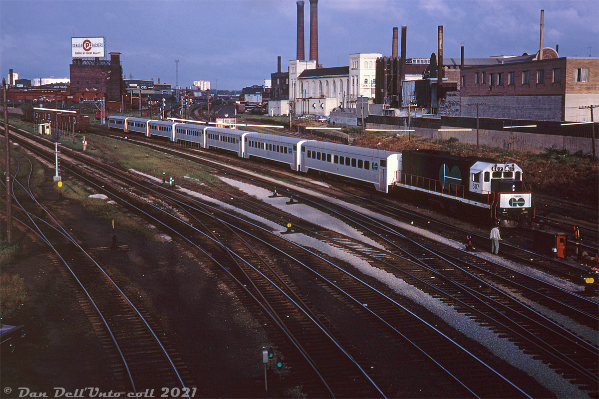
The sun is creeping up at daybreak and casting shadows off the bridge at Bathurst Street as a morning inbound GO Transit commuter train, lead by GP40TC 607, rolls into the Toronto Terminals Railway trackage at Cabin D (behind the third car) and passes some switchtenders in charge of the manually controlled ground-throws.

This area, from the west limits of the TTR to west of Spadina Avenue was known as the "Bathurst Street Non-Interlocking" zone in timetables. All switches were manually controlled via switchtenders on the ground (rain, snow, shine or heat), with movements co-ordinated by the Cabin D train director. The rest of the TTR territory was made up of automated interlocking plants installed in the 1920's and controlled by John, Scott and Cherry St. towers. The antequated control system at Bathurst Street, a relic from the 1890's, continued to be in use until track re-alignments and upgrades in the early-mid 80's when the new flyunder went in, mainline realignments happened, and Cabin D was removed (the location itself was also renamed from Cabin D to Bathurst Street). The new automated interlocking system was remotely controlled via a panel in the John St. interlocking tower.

Visible is the typical view off Bathurst Street bridge for decades past: in the upper left is Liberty Village, with a Canada Packers billboard ad on the top of the Federal Cold Storage building. Part of the John Inglis plant is visible behind that, adjacent to CPR's Parkdale Yard (note the headlight of a switcher near Strachan Avenue grade crossing). In the middle background is the Toronto Municipal Abbatoir/Quality Meat Packers, and on the right were some buildings once home to Consumers Gas. Most of the area around Bathurst Street interlocking has undergone extensive gentrification and redevelopment, and looks quite different even from what it looked like in the late 2000's.

Original photographer unknown, Dan Dell'Unto collection slide.
Copyright Notice: This image ©Unknown, Dan Dell'Unto coll. all rights reserved.


Caption: The sun is creeping up at daybreak and casting shadows off the bridge at Bathurst Street as a morning inbound GO Transit commuter train, lead by GP40TC 607, rolls into the Toronto Terminals Railway trackage at Cabin D (behind the third car) and passes some switchtenders in charge of the manually controlled ground-throws.

This area, from the west limits of the TTR to west of Spadina Avenue was known as the "Bathurst Street Non-Interlocking" zone in timetables. All switches were manually controlled via switchtenders on the ground (rain, snow, shine or heat), with movements co-ordinated by the Cabin D train director. The rest of the TTR territory was made up of automated interlocking plants installed in the 1920's and controlled by John, Scott and Cherry St. towers. The antiquated control system at Bathurst Street, a relic from the 1890's, continued to be in use until track re-alignments and upgrades in the early-mid 80's when the new flyunder went in, mainline realignments happened, and Cabin D was removed (the location itself was also renamed from Cabin D to Bathurst Street). The new automated interlocking system was remotely controlled via a panel in the John St. interlocking tower.

Visible is the typical view off Bathurst Street bridge for decades past: in the upper left is Liberty Village, with a Canada Packers billboard ad on the top of the Federal Cold Storage building. Part of the John Inglis plant is visible behind that, adjacent to CPR's Parkdale Yard (note the headlight of a switcher near Strachan Avenue grade crossing). In the middle background is the Toronto Municipal Abbatoir/Quality Meat Packers, and on the right were some buildings once home to Consumers Gas. Most of the area around Bathurst Street interlocking has undergone extensive gentrification and redevelopment, and looks quite different even from what it looked like in the late 2000's.

Original photographer unknown, Dan Dell'Unto collection slide.

Photographer:
Unknown, Dan Dell'Unto coll. [936] (more) (contact)
Date: Circa September 1968 (search)
Railway: GO Transit (search)
Reporting Marks: GO 607 (search)
Train Symbol: Not Provided
Subdivision/SNS: Bathurst Street - TTR (search)
City/Town: Toronto (search)
Province: Ontario (search)
Share Link: http://www.railpictures.ca/?attachment_id=44405
Click here to Log-in or Register and add your vote.

13 Favourites
Photographers like Gold.Log-in or Register to show appreciation
View count: 1110 Views

Share this image on Facebook, Twitter or email using the icons below
Photo ID: 43178

Map courtesy of Open Street Map

Full size | Suncalc
Note: Read why maps changed. Suncalc.net for reference only.

All comments must be positive in nature and abide by site rules. Anything else may be removed without warning.

One Comment
  1. Nice! Early GO was an experience – those little square paper tickets – good luck if you lost it enroute!
    And early GO lives on: a ride on the ONR north to Moosonee will allow you a Hawker Siddeley built experience. Likewise should the Agawa Canyon train operate ever again (!).
    sdfourty

Railpictures.ca © 2006-2023 all rights reserved. Photographs are copyright of the photographer and used with permission
Terms and conditions | About us