Welcome Visitor. First time here? Like what you see? Bookmark us for when you are bored, and check out 'top shots' and 'fantastic (editors choice)' in the menu above, you won't be dissapointed. Join our community! click here to sign up for an account today. Sick of this message? Get rid of it by logging-in here.


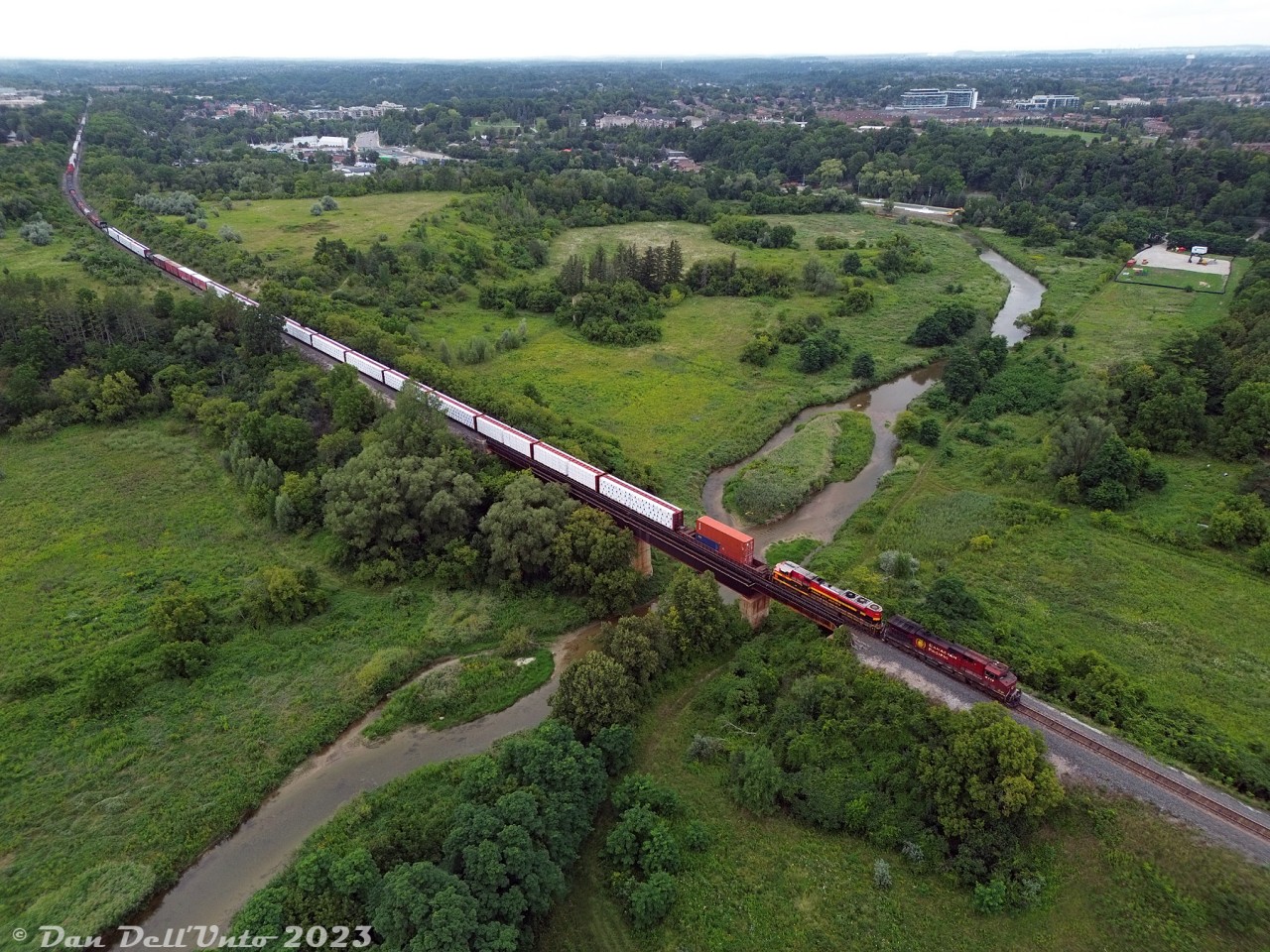
CPKC train #420 makes its way south down the MacTier Sub, crossing the mighty Humber River south of Woodbridge on the approach to Emery. Today's power is CP AC4400CW 9713 and KCSM SD70ACe 4163.

CP's Humber River bridge at Mile 10.48 MacTier Sub was constructed as part of one of the old line realignments around Woodbridge: the original Toronto, Grey & Bruce line snaked through the lower part of the valley here and crossed the river at a lower bridge*, until straightening and elevating the line for the present high-level bridge shown. The original TG&B line at the upper left also kept going straight off to the left (to out of frame) at the present curve, once entering Woodbridge on a more westerly alignment. This was realigned east to the present alignment (north of the curve, heading into the distance) around 1907-1908, and the north end of the old alignment became a short spur into town.

And if that wasn't enough, the old Toronto Suburban Railway interurban line from Weston to Woodbridge snaked along the Humber River through the valley here until its discontinuance in 1926. (A look at some old aerial imagery from 1961 shows a few of the old alignments from both.

* That small white square, visible poking up in the Humber River north of the "island" on the east side, may be an old bridge abutment from the original alignment.
Copyright Notice: This image ©Dan Dell'Unto all rights reserved.


Caption: CPKC train #420 makes its way south down the MacTier Sub, crossing the mighty Humber River south of Woodbridge on the approach to Emery. Today's power is CP AC4400CW 9713 and KCSM SD70ACe 4163.

CP's Humber River bridge at Mile 10.48 MacTier Sub was constructed as part of one of the old line realignments around Woodbridge: the original Toronto, Grey & Bruce line snaked through the lower part of the valley here and crossed the river at a lower bridge*, until straightening and elevating the line for the present high-level bridge shown. The original TG&B line at the upper left also kept going straight off to the left (to out of frame) at the present curve, once entering Woodbridge on a more westerly alignment. This was realigned east to the present alignment (north of the curve, heading into the distance) around 1907-1908, and the north end of the old alignment became a short spur into town.

And if that wasn't enough, the old Toronto Suburban Railway interurban line from Weston to Woodbridge snaked along the Humber River through the valley here until its discontinuance in 1926. (A look at some old aerial imagery from 1961 shows a few of the old alignments from both.

* That small white square, visible poking up in the Humber River north of the "island" on the east side, may be an old bridge abutment from the original alignment.

Photographer:
Dan Dell'Unto [993] (more) (contact)
Date: 08/14/2023 (search)
Railway: Canadian Pacific Kansas City (search)
Reporting Marks: CP 9713, KCSM 4163 (search)
Train Symbol: CP 420 (search)
Subdivision/SNS: Woodbridge - CP MacTier Sub (search)
City/Town: Vaughan (search)
Province: Ontario (search)
Share Link: http://www.railpictures.ca/?attachment_id=52782
Click here to Log-in or Register and add your vote.

6 Favourites
Photographers like Gold.Log-in or Register to show appreciation
View count: 616 Views

Share this image on Facebook, Twitter or email using the icons below
Photo ID: 51474

Map courtesy of Open Street Map

Full size | Suncalc


All comments must be positive in nature and abide by site rules. Anything else may be removed without warning.
No comments yet, be the first by adding yours below

Railpictures.ca © 2006-2024 all rights reserved. Photographs are copyright of the photographer and used with permission
Terms and conditions | About us