Welcome Visitor. First time here? Like what you see? Bookmark us for when you are bored, and check out 'top shots' and 'fantastic (editors choice)' in the menu above, you won't be dissapointed. Join our community! click here to sign up for an account today. Sick of this message? Get rid of it by logging-in here.


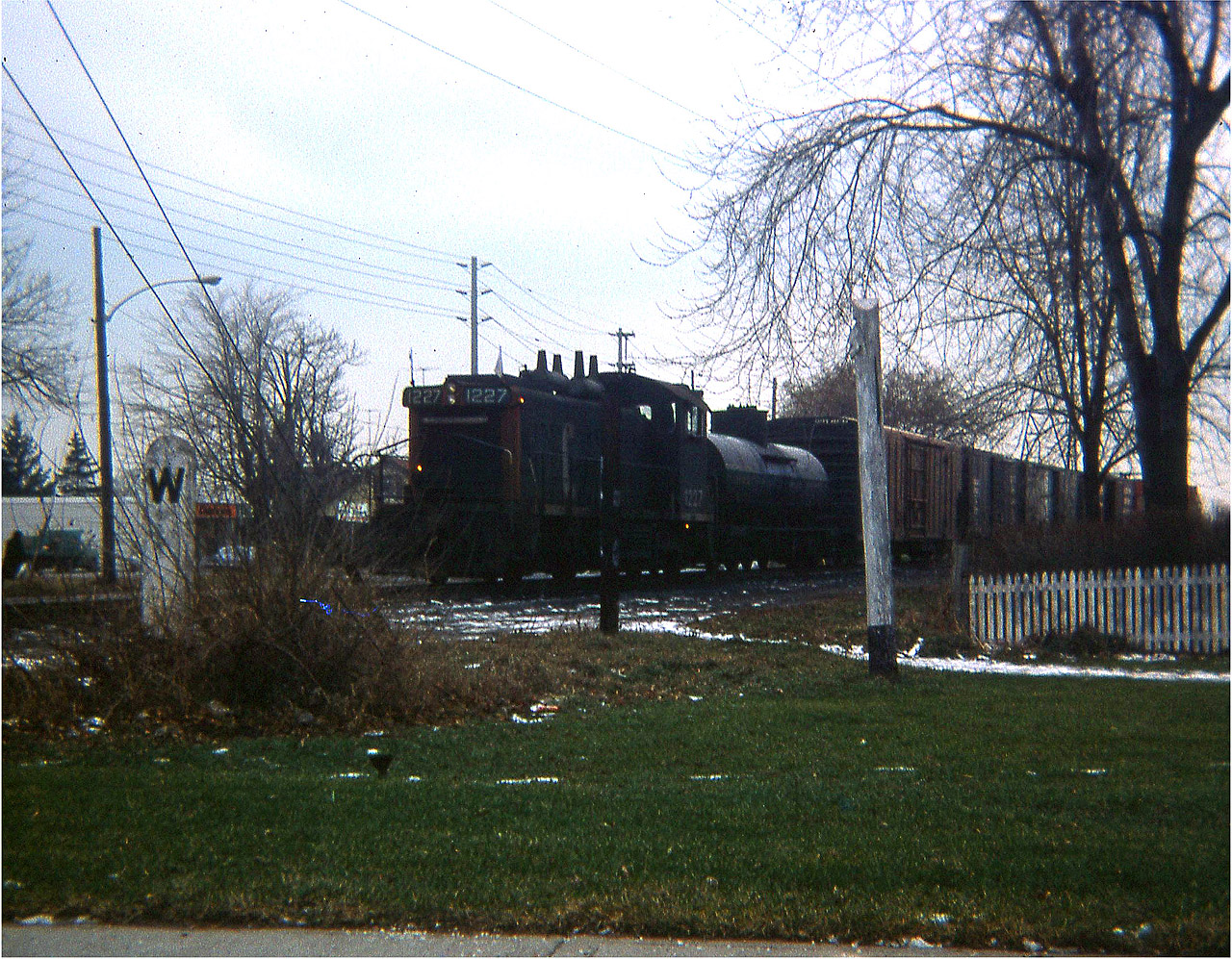
A long time back I had a really lousy little camera, a square shooter no less, and the very worst was to take a lousy camera out on a lousy day and see something good. And this happened. I had lost my old "Hawkeye" a couple years previous and still had not saved for a replacement of decent quality. So this image is the best I could do this day, despite one of the dedicated members of this group enhancing the image you see. I consider this a rare shot. CN 1227, one of the fleet of SW1200RS units, is seen pulling a lone tank and a string of boxcars up from the commercial establishment down by todays' Confederation Park in Stoney Creek. The Beach Line used to run from a connection with CN at Lake St, Stoney Creek, over the Traffic Circle, all along the beach and up to a connection with the CN main at Burlington (West) junction. When the Circle was replaced with the modern interchange at Centennial Parkway in 1969-70; the line became just an industrial run to what I remember as Langs Frozen Foods; the building still exists on the north side of the QEW between the Pwy and Burlington St exit.
In this view, taken from Elgin St looking toward Lakeshore Rd, one can see Brock St in the background, the business structure still there today. This track is long gone, and is a parking lot for an apartment building since constructed just off to the right in the photo. The line used to be busy, a passenger/freight station existed in close proximity around 75 years ago. The fact trains ran thru here once is almost all forgotten. (I wonder what happened to that nice concrete Whistle sign?)
Copyright Notice: This image ©A.W.Mooney all rights reserved.


Caption: A long time back I had a really lousy little camera, a square shooter no less, and the very worst was to take a lousy camera out on a lousy day and see something good. And this happened. I had lost my old "Hawkeye" a couple years previous and still had not saved for a replacement of decent quality. So this image is the best I could do this day, despite one of the dedicated members of this group enhancing the image you see. I consider this a rare shot. CN 1227, one of the fleet of SW1200RS units, is seen pulling a lone tank and a string of boxcars up from the commercial establishment down by todays' Confederation Park in Stoney Creek. The Beach Line used to run from a connection with CN at Lake St, Stoney Creek, over the Traffic Circle, all along the beach and up to a connection with the CN main at Burlington (West) junction. When the Circle was replaced with the modern interchange at Centennial Parkway in 1969-70; the line became just an industrial run to what I remember as Langs Frozen Foods; the building still exists on the north side of the QEW between the Pwy and Burlington St exit. In this view, taken from Elgin St looking toward Lakeshore Rd, one can see Brock St in the background, the business structure still there today. This track is long gone, and is a parking lot for an apartment building since constructed just off to the right in the photo. The line used to be busy, a passenger/freight station existed in close proximity around 75 years ago. The fact trains ran thru here once is almost all forgotten. (I wonder what happened to that nice concrete Whistle sign?)

Photographer:
A.W.Mooney [2134] (more) (contact)
Date: 12/xx/1974 (search)
Railway: Canadian National (search)
Reporting Marks: CN 1227 (search)
Train Symbol: beach local (search)
Subdivision/SNS: CN Beach Sub (search)
City/Town: Burlington (search)
Province: Ontario (search)
Share Link: http://www.railpictures.ca/?attachment_id=27531
Click here to Log-in or Register and add your vote.

19 Favourites
Photographers like Gold.Log-in or Register to show appreciation
View count: 2312 Views

Share this image on Facebook, Twitter or email using the icons below
Photo ID: 26374

Map courtesy of Open Street Map

Full size | Suncalc
Note: Read why maps changed. Suncalc.net for reference only.

All comments must be positive in nature and abide by site rules. Anything else may be removed without warning.

4 Comments
  1. I have spent too much time at Spencer Smith park with my kids and it is hard to imagine a rail running “through” it as it should have on the west end….

    This gives me advanced appreciation for once was. My memories of the Beach sub are there but vague, it was gone whenI was young.

  2. I remember the track being in place but never saw a train on it. Was the railway bridge a lift bridge or a swing bridge?

  3. I believe it was a swing bridge (with the roadway) until a boat hit it around 1954. The orange bridge you see on the Beach now, the one that is ALWAYS breaking down, carried the track on the lake side of it. Since it was removed the roadway was widened.

  4. In regards to the Canal bridge: It was a Swing Bridge over the Burlington Canal. Replaced in 1962 with the lift bridge we know of today, shared with the road way. CN abandoned the Beach Sub line in 1982.

Railpictures.ca © 2006-2023 all rights reserved. Photographs are copyright of the photographer and used with permission
Terms and conditions | About us