|
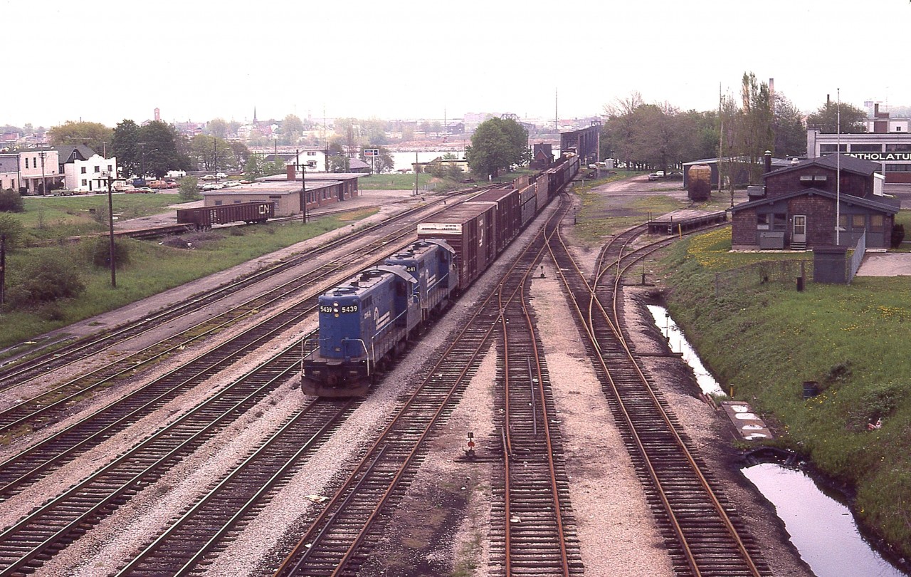
Caption: To clarify the location of the old CN Crew Hostel which I offered up the other day, here is a view of the eastern most part of CN Fort Erie trackage, taken 10 years before the Hostel closed. It can be seen on the right; and the old MCRR/TH&B station on the left, with a Conrail transfer behind CR 5439 and 5441 just coming into Canada. The USA is seen in the far background. Lots to look at here. In the background also, on the right, a yellowish rail car is parked on a stub. This was a Boeing car; one was spotted here on occasion due to the Fleet Aircraft company located nearby.
It is a rather gloomy day, and although this is not a factor, I scribbled in my notes that Mount St. Helens had blown up the previous day. Just a historical note.
|


Nice. And looks to be stretched all the way back to Harbour Draw in the distance. It would be another three years before I worked in that area.
Great ‘aerial’ Arnold! back then, we could make do with just about anything to get that ‘up and away’ photo! Which I assume you’re on the old Central Ave. bridge.
Hostel looks great, and so does the flat roofed, modern TH&B station to the left. Even the old brick Bridgeburg B-1 ‘station’ (or office?) looks great in railway service.
Tell me, where that street ends to the left of the hostel – is that where CN’s old witch’s hat station had once stood? and, when was it demolished??
***correction – “…modern, MCRR/TH&B station….”
This is what bothers me when I see these photos from the past. Notice how many structures there were. All the vehicles parked downtown. Lively buildings. A lively community.
A ford dealer (it’s a car dealer/repair shop now but third party)
While the bunkhouse is gone the “mentholatum” building has activity.
It’s a shame we live in a society that wants to eliminate all signs of what used to be there – the bare minimum with no replacement.
The downtown should be re-developed.
Most of the main drag is boarded up. Station grounds are just a foundation. The track that goes beside the “new” station is still there believe it or not.
The railway was part of the centre of the community. Now it’s just an eyesore. Stay away. No tresspassing!
I believe the Witch hat station was between the Boeing car and the main track. Don’t know when it came down. Guessing 1970. Someone will know.
Keen eye there Stephen. I agree with you.
Every time heading to Silver Creek – F E was a must, and there always seemed to be a Boeing car parked – a different car each time. Great times. Interesting times. Never knew what Penn Central / Conrail power would creep over from the US of A. And Chessie too.
AWM has captured the’spirit’ of those times!
sdfourty
Also I should note that the “fort erie” sign was recently replaced. Two CN signs are now up.
Thanks. Something to look for while down that way since there are hardly any trains. )
)
Todd, you are correct, that is the former location of the CNR station to the left of the hostel.
A great photo. Lots to see.