|
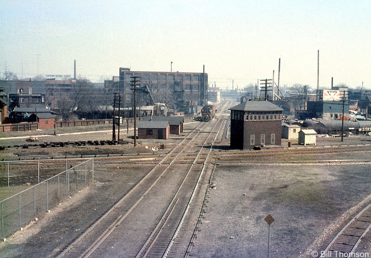
Caption: The CN-CP West Toronto diamonds in "The Junction" are pictured in 1963, looking east from the nearby Weston Road overpass. A short local lead by a CP Alco/MLW switcher is visible on the north mainline of the North Toronto Sub, near the switch to the MacTier Sub that headed north out of town for northern Ontario and the west coast. The West Toronto interlocking tower is prominently pictured on the south-east quadrant, and controlled movements through the junction via a manual interlocking system (note the rods and linkages running from the base of the tower and along the tracks to control wayside signals and switches). The tower would be demolished next year in September 1964, and Centralized Traffic Control (CTC) installed and active by March 1965. A number of section houses dot the northeast quadrant opposite the tower.
West Toronto was a main junction point for CP's lines leading north, east, and west out of the city of Toronto, as well as the location of their West Toronto & Lambton yards and locomotive servicing facilities.
The closest track crossing CP's North Toronto Sub is CP's MacTier-Galt Sub connecting track, used regularly by the "The Canadian" between Toronto and Sudbury (via the MacTier Sub that lead north out of town) until the passenger train was rerouted by VIA the late 70's.
The CP's Galt Sub is visible on the lower right, coming up from downtown Toronto (Union Station, and CP Parkdale Yard) and curving west to lead out of the city for Streetsville, Guelph Junction and lines beyond.
The two mainline tracks running alongside the tower and crossing the diamond are for CN's Brampton Sub, which was their mainline from Toronto to Stratford until it was reorganized in January 1965. The Toronto-Halwest (near Bramalea) section became the Weston Sub, and after many decades this set of diamonds was grade separated in 2014.
The furthest track crossing at the diamonds on the other side of the tower is the lead from the CP MacTier Sub to the "Old Bruce" service track that ran down the east side of the corridor to Dundas Street, serving local industries.
CP's North Toronto Sub disappeared in the distance and cut through Toronto to Leaside, the Belleville Sub, and Agincourt (home of CP's new Toronto Yard that was under construction, opening next year). The opening of Toronto Yard meant much freight traffic and transfers would use the line between the two yards, and also to access the MacTier Sub and Galt Sub leading north and west out of town.
|


Great photo! My father as a boy has a lot of fond memories of standing on that bridge, especially watching steam engines storm underneath.
Memorial shot. I can remember seeing this about as it is shown, minus the tower. I love shots with the old towers in them as they seemed to be the first to go………..
Also interesting the stub track by the corner of the galvanized fence at left – imagine that might be a CN track?
Is that a crossing guard tower for Osler Street in the distance?
Switcher looks to be shoving that cut away from the diamonds; engineer hanging out window to get signals from brakeman/conductor riding the cut. I wonder what industries they’re off to service.
There’s, what appears to be, remnants of a switch coming from National Tire crossing Junction Rd and what looked like it ran alongside Cawthra Rd. Could that spur be from the CN Weston sub and @stephen host and that stub end spur in Bill’s photo be the end of it?
Actually no, I stand corrected. @stephen host, I just googled and have a 1910 map and that stub end spur did come directly off the Grand Trunk (to be CN Brampton, Weston subs respectively) whereas the spur I was referring to came off the, what is now, the CP North Toronto sub west of the diamond.
The 5 storey brick building, to the left of the switcher on the Northeast corner of Osler street the local is crossing, has been demolished. Apparently due to a derailment a locomotive crashed into the building. It was a grain train and all the local wildlife was out for a feeding frenzy. Eventually arson, or a fire of some sort, claimed the building. Now an empty lot. A scene hardly recognizeable now! Thanks for the memories!